08/05/2016

Hiroshima trail running: Ushitayama and Futabayama


Looking south to Hiroshima Bay from Ushitayama
It has taken me some time and distance to be able to write about this run as we were only in Hiroshima because we were fleeing the Fukushima nuclear disaster of March 2011. How paradoxical it was to wind up in Hiroshima, synonymous with the atom bomb and the effects of radiation; but luckily for us friends had offered us shelter for a couple of weeks. I spent most of the time trying and failing to get the authorities and institutions in the city to respond to the crisis, in particular to support the evacuation of children in areas of eastern Fukushima with high levels of radiation. Most are still there in areas that should have been evacuated. Running was a surreal but necessary antidote to the stress and fear of this time, a bubble of normality and beauty....and the gift of temporary forgetfulness.

Ushitayama behind the Ota river and its running path
Hiroshima, like most Japanese cities and towns, is surrounded by hills and mountains and some even poke their heads above the rising tide of buildings within the city itself, protected by their steepness and instability. The horseshoe ridge between Ushitayama and Futabayama is one such survivor, just two kilometers from ground zero and ranged above the Ota river, once full of the bodies of the burned, now the placid companion of joggers and dog walkers. To be in Hiroshima is to inhabit this double identity, the glib present and an inescapable history. It's in the fabric of the place, and literally still, the soil. Sometimes it is necessary to forget for a while, but it is a shame that in 2011 the administration were unable to make the link between Hiroshima's history and the immediate need of Fukushima's children.

A wild boar-proofed flower bed at the top of Ushitayama
I left our accommodation by the river, crossing the busy dual carriageway and ran up through a park with it's incongruous "English Rose Garden" and up a dusty track between signs warning of Inoshishi, wild boar. Signs of their rummaging mastery of this island in the concrete were everywhere at the path side. How quickly the air beneath the trees, their tangled roots and the need to push against gravity worked their everyday magic, the weight of what was happening falling away as my mind was forced to concentrate on balance, co-ordination and finding my way along unknown paths.

Looking east from the ridge

Looking south across downtown Hiroshima
Someone had adopted the top of the hill and made a shelter and flowerbeds. What a nice haven this must be for people living below with little space and no garden. It looks as if people people walk up here and take in the space, free for an hour or two. Over a couple of runs I realized that a ridge formed a semi-circle, with some kind of temple structure on a hill at the far end. I went back and made a circuit of it.

Futabayama crowned by the Peace Pagoda
Futayaba's cemetary and Peace Pagoda with ground zero beyond
As I reached the small area of flat ground near the top of Futayaba I was alarmed to see a big German Shepherd dog jumping up at a man. He was wearing a padded arm and was training the dog to attack. Why? Who was he? An off-duty policeman and his dog, or someone injecting some power into his life through control? A potent symbol in any case, especially next to the ethereal structure only meters away.

Futabayama Peace Pagoda which is in the form of a large Stupa
Dropping into the streets again the schools were emptying, ordinary life unaccountably continuing as if Fukushima was a different country far away with no common history. It can't be understood, but at least there is the consolation of the hills and the simplicity of good food. In Hiroshima that can mean Okonomiyaki like this small local specialist cafe that we found.


Hiroshima City were not yet providing accommodation for evacuees, so we had to move on. I returned to exhibit my collaborative portraits of Fukushima's children at the invitation of the organisers of the annual Peace exhibition and met and drew some Hibakusha  (atom bomb survivors). There I also met activists whose dedication and compassion showed another side of the city.


More on the stupa:
http://gethiroshima.com/museums-attractions/peace-pagoda/
My blog on living in Fukushima:
http://livinginaizu.blogspot.co.uk/


16/01/2016

Running the Mt Takao to Mt Jimba trails

Mt Fuji with a cloud cap in the distance to the south west, seen from the route
Thanks to first time visiting runner Michal who sent photos and a report on his recent run from Takaosanguchi station on the western edge of Tokyo - his gpx file is at the end of the post:

"My recommendations for someone running it for the first time would be to start from Takaosanguchi station; there are shops for water, lockers, and an English-friendly information office with maps etc. and it is easy to get there from Tokyo, for example from Shinjuku. I took route number 5 up and down Mt Takao, which was pretty nice and mostly runnable. From Mt Takao to Mt Jimba there are good markings, but while some are bi-lingual, some are only in Japanese; it's therefore best to memorise the Kanji characters, for example as on this sign:

Sign on Takao-san with approximate walking times - fit runners might take around one third of these times

For many of the hills on the route there are options to go up over the hill or around it with the a more contouring path which re-joins the ridge path later - the latter is usually the more runable option.

The view back East towards the Kanto plain and Tokyo from Takao-san

It's easy to get water at shops or toilets at Mount Takao and Mount Jimba plus several other places in between, but decent food options are limited. There is a new, really good onsen directly attached to Takaosanguchi station (1000 yen entrance fee, 150 yen for towel rental), which is great for post-run recovery!


A shorter alternative to doing the out and back course is to run down to the main valley road south of Mt Jimba (maybe 20 mins running?) where I have heard there is a bus that goes back to Takaosanguchi station. It might be best to check at the information centre before starting though.

The summit of Mt Jimba with its memorable horse statue -the turn-around point on this route

GPX file for the Takao-san Jimba-san out and back route
"Note that I was doing extra “loop” on the way and I got lost in a minor way a few times, so it might not be perfect, or may require corrections. But it gives you an idea of elevations etc. Michal"

Thanks Michal! For other ideas for running near Tokyo click here

02/01/2016

Trail and mountain runs near Tokyo

Looking for trail and mountain runs near Tokyo? I'm often asked about this, so here are a few ideas:


The best hills to do within a day when in Tokyo are are on the west side, and if you have an early enough start you should be able to get back in the afternoon. They are mostly less than 1000m high, and you can choose to make it as easy or tough as you like. The stations to start from are marked in red. For example:

Musashi-itsukaichi station on the JR East Itsukaichi Line
The Okutama area: Hinode-san to Odake-san and back – nice undulating ridge running. This post is from that area: http://trailrunningjapan.blogspot.co.uk/2013/02/mitake-mountain-trail-race-tokyo.html
Or here is someone's linear route using different station
There is a prestigious 71km race using this area called the Hasetsune Cup with an English webpage: http://www.hasetsune.com/en/cup/


On Hinode-san in winter with Taku and Kick

Odake-san

Takaosanguchi Station on the Keio-Takao Line

Mt Jimba via Takao-san

Ome station on the JR East Ome Line
Head north west for  Takamizu-san. It is also a race course: http://www.kfctriathlon.jp/html/event_trail.html#2009_takamizu_trail

Even ex-international orienteers like Alessandro need to stop and look at the map sometimes! Near Ome


Higashi-Agano Station on the Seibu-Ikebukero Line
Trails to the north for Koruyama-san-taki and Kamakitako lake see this post: http://trailrunningjapan.blogspot.co.uk/2014/06/running-from-kamakita-lake-and-kuroyama.html

A hot runner cooling down under Shukuya no Taki near Kamakitako: me

Seibukyujo-Mae Station on the Seibu Sayama Line
For runs round Tayama and Sayama lakes and woodland - rolling trails and roads, an oasis within the city - not mountain but OK if you are short of time.

I advise your to buy a map of the area (Mapple Yamachizu series), and if time is an issue doing an out-and-back course is safer than doing a circle or point-to point when you don't know the area. The navigation is up to you, but I advise a map and compass and take time to match the signs with the map – all mountain trails in Japan can be complicated, especially if you don't read Japanese, so allow time for checking as you go along. Mistakes will occur!

Enjoy, and please send photos and a report to go on the website to help other runners who come later. 

Please note: a certain amount of radiation from the Fukushima Daichi disaster reached this area. Please research the risk before eating local food or drinking from springs.

30/12/2015

Hayama trail runs: Sengenyama-Moritogawa-Futagoyama

Hayama is a town in Kanagawa on the northern western edge of the Miura peninsular facing Sagami bay. Thanks to Russian trail runner Inna for sending these photos and a report on her local run from Sengenyama (仙元山) to  Moritogawa (森戸川) to Futagoyama (二子山). It's a good example of how there are nice trails to run in Japan even near towns, in areas that are not well known for mountains.


"The top of Sengenyama is usually busy during Sakurami (cherry blossom viewing time). The view is spectacular. The start point of this trail can be the Hayama shogakkou bus stop (coming from Zushi JR or ShinZushi on the Keikyu line). Or it can be started from the other side of Sengenyama by the French bakery called Bounjour."

Inna points to one of the hand drawn and faded signs

A sign for the Moritogawa river in the valley between the two hills


Futagoyama means twin mountains - you can see why

"The finish point is the Kawakubo (川久保) to Nagae kousaten (長柄交差点) and from there you can walk or take a bus to Zushi JR station (逗子駅) or Shin Zushi (新逗子駅) station on the Keikyu line."
The top of Futagoyama 207.8m


Running with a dog on the mountain trails of Japan

I was kindly contacted by Inna, a Russian woman who has lived in Japan for 20 years and enjoys running with Angie, the Dalmatian originally from the international school where Inna teaches. I asked her what it was like running with a dog on the trails around Kanagawa prefecture:

"I was a road and marathon runner, but now I am very much into trail running. Angie is a school dog and when I began taking care of her she could not run more than 3-5 km. Now we run on the trails for between 3 and 5 hours. I am happy for Angie, since on the trail I let her off the leash and she is healthy, strong and protective.

Most of the people on the trail are rather friendly or at least neutral towards Angie. I had one difficulty: when we were running every morning over the Sangaoka, there was a man regularly running at the same time us. Angie would always bark at him, I don't know why. I just changed my running time so that she didn't stress him.

Angie waiting for Inna at a path junction

The amazing thing about the dog is that when we are on a new trail, she stays close to me, usually within 5 to 10 meters, always within sight. When the trail is familiar, or we run back the way we have come, Angie runs far away and I have to call her from time to time to make sure she is there. What amazes me the most is that she remembers all the junctions on the way back. She leads. She is always in front, just on new trails she waits for me at the junctions.

Inna like's to run by the Moritogawa river in Hayama, Kanagawa prefecture, especially in summer:
If you like me run with the dog you don't have to worry about your dog getting dehydrated. Mine loves to swim, drink and play with the water. She is very funny when she tries to chase birds or squirrels from the river.

I would love to get a Doberman and run with him and my Angie all over Japan's trails."
___________________________________________
What are your experiences of trail running in Japan with a dog?

For the ultimate website on running and climbing Japanese mountains with a dog see:https://hana2009.wordpress.com/  He gives detailed advice about being on Japanese mountains with  a dog in the comments section here: https://hana2009.wordpress.com/about-2/
___________________________________________

22/06/2014

Running from Kamakita Lake and Kuroyama San Taki, Saitama

Taku-san by two of the waterfalls


At the western fringes of Saitama, north of Tokyo are forested hills. Tucked into corners of these otherwise modest mountains are beautiful waterfalls and hidden statues to mountain aescetics or Yamabushi, solitary monks who lived there. I only gradually discovered this run which links some together, before I had any proper maps, by struggling with a few of the unhelpful leaflets you get at railways stations. They didn't meet up or overlap, so it was fun going back until I had worked out how the complex landscape fitted together: I frequently went astray but was always glad to be in the cooler green shade and away from the baking heat of the Kanto plain. The area is well used by walkers, and crossed by small roads, but the hill-sides can be steep and loose so it is important to stick to trails.

Guardian figure by the Yama-jin statue, on a ridge SW of Kuroyama San Taki


The most extraordinary discovery I made was the cluster of statues, on a ridge beneath huge broad-leaf trees which had been spared the axe in the waves of woodland clearance and plantation which have stripped most of this region of it's native trees and replaced them with commercial crops with precious little diversity. On a little-used path pitted with holes made by wild-boar rooting for food, I came across the carvings beneath a tremendous green canopy and wondered why they weren't marked on the leaflet. But they were all the better for that.

Kamakita Lake, in Iruma district, west Saitama
My usual starting point for a run was Kamakita Ko lake, which has a car park, complete with wild cats and a toilet. The lake is a man-made one constructed in 1935, with a monstrosity of an abandoned concrete hotel at one end. Still, it is in a nice setting considering you are escaping the horrors of Tokyo. There is a youth hostel, and trails lead off in several directions, including a nice one if you go out of the top of the park area SE behind the car-par, over into the next valley, left down the road, then right up the path by the stream that leads to a beautiful small waterfall with a clear drop and a pool ideal for cooling off in hot weather, called Shukuya no Taki.

Shukuya no Taki - it feels fantastic battering down on your shoulders
 
I ran around here for years on my own before being able to discover any information about trail races or meeting any other runners, so it was nice to be able to go back later with Taku-san and Kik-san from Tama Orienteering club and show them the sights - they normally run further south.

Taku-san and Kik-san descending towards Kuroyama San Taki
Taku-san by the third of the three waterfalls


Koruyama san Taki (The black mountain with three waterfalls) is best approached from the hills above it. The closed road below it leads up through stalls and places selling the local fish, with a small temple next to the waterfalls, which have been co-opted in the usual fashion. I was swayed by the magic of hearing chanting and a drum in that special place and became quite moist-eyed until I noticed the monk's ride: a large new and white Mercedes. I guess they don't know anything we don't know after all.

Getting there: Apart from cycling or driving to Kama Kita Lake, Oyagi, Iruma-gun, you can get the train to one of the stations to the East or South of this area and find trails into it. For example this route. You can also park below Koru Yama San Taki (marked with a circle with three dots in the map below) by driving up the next valley to the north of the lake. Happy running, Geoff

24/05/2014

Aapo hits the trails in Japan

Aapo, a runner from Finland who was top 50 in world orienteering as a junior and visited Japan recently sent me these photos and notes from his runs in Kyoto, Shikoku and Saga - thanks Aapo!

Running north of Kyoto: Mount Kurama near Kuramadera Temple
The picture above is from the top of the hill on a hiking route. The picture looks to the east. I followed that trail and had a nice one hour run on a soft trail, returning the same way. Location map

Running trail in Shikoku: Yamashirochō Nobumasa, Miyoshi-shi, Tokushima-ken

There are some nice soft trails in this area (above) and if one just keeps going up to the mountains by passing by some houses one may find nice forest trails going a long way. Location map

Running trail in Kyushu: Mount Kora (Korasan), by Karume City, Saga Prefecture

This is a natural mountain area which is nice for hiking and there are trails to run :) The picture above gives a nice taste of what it is like: location map. However this might be a good parking place and starting point. There is a trailhead up towards a peak near the temple that is close to the parking.

Aapo, Finland

More from Aapo:
www.facebook.com/aaposummanenurheilija
http://aitoaelamaa.blogspot.fi

13/02/2013

Mitake Mountain Trail Race, Tokyo

15km 762m/2,500 feet of climb (Mountain top finish) November

GAMBARE! Run! Lunge up endless steps, gongs beating in your ears and stagger a last few paces as if through treacle. Book-keepers wait in judgement, a banner swims overhead- why can’t you read it? Higher still looms a huge silver warrior on horseback, sword poised to lop off the heads of those below. You want to shout, to warn them, but they can’t understand and you laugh manically as you sink to the ground. No, it’s not just another running anxiety dream and you aren’t loosing it. It is a Japanese mountain race … and that’s only the finish….

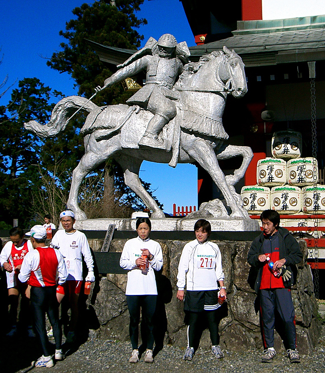
The finish is at Mitake-san's mountain-top shrine


Tokyo may excite the techno-urbanite, but it’s flat, it’s enormous and it’s very, very ugly. (Even I think that and I come from Rochdale.) Sanity demands that the fell runner gets the hell out. Fortunately, most of Japan is covered by beautiful mountains, some of which are only an hour to the west of Tokyo. The modest spot heights and wooded trails with neat signposts are deceptive. This is forest you can fall off. Being geological babies these ‘hills’ are sharply ridged and craggy, suddenly requiring concentration after easy running. Mountains are venerated with the suffix ‘san,’ each with it’s shrines and offerings, each feature with it’s own god of place and a sense of awe befitting a land that can shake itself like a dog scratching fleas.

Running ‘off piste,’ even on these modest hills, is not a good idea, as I have found to my cost. Flesh-ripping scrub, funnelling down into dangerous gullies tends to focus the mind on navigation a little more. And when the animal warning signs depict snakes, hornets, monkeys, boar and bears, you start to hanker for something cute and homely, like an aggressive farm dog. Winter is the best season below the tree line, otherwise you might sweat up 3,000’ and see nothing but leaves - and in winter some of the wildlife is safely asleep.

Until this visit I hadn’t seen another hill runner or been able to find a race to run. I finally managed to get a late entry for the Mitake Mountain Trail Race in November, the last of the season. A recce revealed a fast 15k/2,500’, very runnable course, with two thirds of the climbing on tarmac in the first 4km and a mountain top finish.

Early morning on race day found us shivering at the Mountain railway start. The entire field duly lined up, not to run, but for a full half-hour of synchronised group aerobics! We are talking Lycra clad women instructors with a sound system here. They all looked to be enjoying it but it was a star jump too far for me.

Pre-race exercises anyone?

According to the organiser’s map there was one short, rough technical downhill stretch to look forward to on the course, which mainly climbed, but I was stunned to find a ‘No overtaking’ instruction on this section! Hell, descending is the only thing I can still do. After clarification it seemed that overtaking was acceptable, provided permission was politely sought from other runners—this reprieve interrupting the rather less than polite string of epithets in my mind.

After photos with a splendid man in his seventies running with a flag calling for peace in Afghanistan; and another with my wife's uncle (clad in full black motorbike leathers set off by a girl’s borrowed fluffy blue hat) the start was called. The only other ‘Gaijin’ (foreigner) grabbed me and said hello, then we were all off to the beat of a large Taiko drum, the leaders disappearing round the hairpins, led by a forestry safety worker on a motor-cross bike in bright red leathers (but sadly no fluffy hat.)

The start, with the winner in yellow

Pacing yourself up a 1,000’ climb on tarmac is tricky and the second half on trails was spent hanging on, being passed by the odd runner—they were all thinner and more poshly dressed than me—not difficult on both counts, so perhaps I was the odd runner. Still, the sun striped through the trees, the air was crisp and good, the first time up the steps of the shrine was a novelty and the waterfall sparkled beneath pine-topped cliffs. Finally I was mountain racing… in Japan!

Things were getting painful by the bamboo fringed ridge path heading back towards the shrine, with runners chatting as they trotted by. I was looking forward to the short downhill section. I let my Walshies do the talking as I hit the descent, scattering gravel and sticks and shouting polite apologies to the string of somewhat shocked runners who kindly (and sensibly) got out of my way. I think it was their first encounter with English style descending.

Allesssandro nabbed first gaijin kudos by re-taking me just before the finish on top of the shrine steps for 25th and 26th place from 300. I’ve had a slight ME induced dip in form of late…ok, ok, so it’s a seventeen year dip…so this was good enough.

Alessandro turned out to be a 26-year-old who had been in the Italian orienteering team as a junior. He introduced himself and invited me on a run with his Japanese club before disappearing for the onsen (hot volcanic spa bath,) which came free for all finishers, along with a sweatshirt and numerous spot prizes.

I chose the English option—stay dirty and eat lots of food. Hot noodles in the sunshine; panoramic views across the hills to the vast plain of Tokyo greying to nothing in the distance; oh yes, that'll do nicely. Pushing our son back up the hill in his buggy for the prize-giving at the shrine: oh no. Entertainingly, most of the prizes were decided by an innocent, mystifying and protracted communal game resembling ‘paper, scissors, knife,’ with groans and cheers all round. Passers-by became embroiled and even got prizes. "Jan, ken, PO!"

That night saw us at home, being presented with an enormous celebratory strawberry and cream cake by my wife's uncle. He is affectionately known as ‘Mr Cakee’ for his custom of bringing ever-bigger cakes at every visit. On the top was the legend in chocolate ‘Have view of next champion.’ You’d need a bloody enormous pair of binoculars, mate.

With Alessandro on a later run in the mountains west of Tokyo from Ome


The club run a week or two later was a stonking three-and-a half hours which got faster and faster as slower runners peeled off for shorter routes, leaving a group of four of us, the pace being set by ultra-distance specialist and club captain Taku-san. He had finished 3rd in a 70k mountain race the month before despite his six-days-a-week, twelve-hours-a-day job. We played a game of ‘crack the newcomer’ as he eased the pace upwards at every rise and kept it there, drawing shouts and groans from Allessandro and a handy looking young Japanese runner. This felt faster than the race by some way but we finished together so I managed to keep my dignity and granite-hewn northern silence.

I learned on further runs that shouting ‘Itai, itai,’ (it hurts!) or ‘Damei’ (stop it!) is traditional and if Alle’ is anything to go by, with Italians too. Such ritualised groaning is not to be confused with actual exhaustion—they don’t slow down! At one point Alle’s groans were such that I expected to turn round and see him holding a baby.

Trail running on Hinode-yama Tokyo Japan
Training with Taku-san and Alle on Hinode yama, with Mitake-san behind

Another slight difference from the average British club-run was getting naked in the onsen together afterwards. There really is no better way to finish a winter day on the mountains! After one previous memorable snowy walk we sat outside, up to our necks in steaming water beneath a huge mountain moon. On a hot summer night I have had a small, unfenced campsite onsen to myself at midnight, looking up into the trees with increasing nervousness as I realised the lack of any barrier. I was a ready to eat boil-in-the bag bear snack.

All things must end, and an ill-advised half marathon along with 8,000 Tokyites a little later (flat, dull, windy with a sandstorm in the finishing field) saw me injured once again… bugger, and I was just starting to enjoy myself. Ah well, back to limping overweight and half-trained through the mud and sleet of an English ‘spring,’ back to sloshing off in a cold stone horse trough, back…home.

This article first appeared in the UK Fellrunner Magazine in 2007

24/07/2012

Mt Kongo Climbing Challenge Trail Race, near Osaka, Kansai - April

Mt Kongo, south of Osaka - seen from Katsuragi-san


35km, 2,000m of climb and descent on fast runnable paths (22 miles / 6,000ft) 2012 winning times: men 3.14.45 (439 finishers), women: 4.44.18 (83 finishers), veteran men over 45: 3.59.12 (307 finishers). Total finishers: 829 (1016 starters).

I seem to be making a habit of ending up in the last group to start in 'wave start' races - an especially bad idea when there is a walking event tagged on to the race. 35km of trail filled with walkers and runners adds up to an awful lot of overtaking and apologising (around 2,000 times!), so if you know the route, get there really early and go in the first group off - I tell myself....again! Most of the front runners were in the early starts, though I'm impressed to see that some fast times were done from the back, so it can be done.

One of the last groups of 50 to start
Kongo-san is the name used for a well known and often walked group of mountains on the south east edge of Osaka. The ridge is not particularly interesting or dramatic, and the paths are fast and runnable, with most slopes covered in pesky steps. No doubt some of paths on the flanks are more testing and attractive. The race, the 38th Kongo Climbing Challenge, started at the small park 1km NW of Nijojinja station, went over the saddle just south of Nijo-san, then joined the main ridge over to Mt Katsuragi, Kongo-san, and the ridge heading south then south-west from there, before descending into the valley to the north and following the road to finish at Anami station.

Full of people on race day - keep to the sides
I jogged the course slowly the week before (and took the following photos) - and was passed by a whip of a runner steaming along at race pace - I guessed he would be in the first few come the day. He wasn't for chatting and flew past which emphasised the bad day I was on - cheers mate. It was good to know where I was going and how quickly to start, though I still had to ask at one confusing junction. Before answering the two young women I asked cried out 'Sugoi! Samui desu ka?' (Fanatastic - aren't you cold?), which is compulsory when faced with a foreigner in shorts and a vest when most are still wrapped up.

Mt Katsuragi 968.9m - good views from the top but not much to look at

Having checked the course makes it seem to pass more quickly in the race. It also taught me that on the uphill stepped sections it was often quicker and easier to find trods through the trees to one side. One way or another I was passing people all the way, and feeling good in the fresh sunny conditions.

A concrete and dirt road leads up this valley towards Mt Kongo, 1,125m
Although the course has 2,000m of climbing a lot of it is in undulations, the main climbs being up onto the ridge, up Kasuragi-san, and up Kongo-san. After Kongo-san there is very little climbing and the path gets more attractive as this section is less walked.

Steep stone steps around half-way - tricky when full of nervous joggers and walkers
There isn't any technical terrain, and the only steep rough section with stone steps was so full of people it was hard to let rip, and a marshal was there warning us to be careful (aw, sweet). I gave it a go, though, as is my wont, and put the wind up a few nervous souls. If they ever organise a championship series in Japan they would have to select race only events - walkers really cramp your descending style.

Gentle joggle checking the second half of the course, with bear bamboo
After Kongo -san I had worked through the field and thankfully it got a bit quieter, with mainly just runners to pass on the increasingly pleasant and less engineered paths, sometimes on springy leaf litter with dappled sunlight. OK, time to get going.

Run me, run me...
I was feeling good now, having paced myself correctly, and enjoyed pressing on, using each group I came up behind as a target. I caught up with a guy I had chatted to on the train on the way there whose start time was half an hour earlier. "Let's run together - two people are faster than one!" he said. That's sometimes true, but I was on a roll and sadly he was soon out of the back. Sorry mate. I concentrated on working hard uphill on the small undulations along the last ridge, knowing that the descent and road run-in would be OK whatever state I was in.

The final ridge SW from Mt Kongo
I was looking out for the turn sharp right off the ridge, and found that fortunately it was the one I had reccied the week before. Jumping down huge steps fit for giants made for painful thighs, but once on the valley road it was just a few kilometres blast to the finish. Everyone was lounging around in the sunshine, and I bumped into the guy I had run part of the Mt Rokko race with 3 weeks before. He turned out to be a hard-working fireman. A couple changed from their immaculate running gear into their immaculate going home gear, carefully brushing their already clean shoes before walking to the station.

Most of the course seen from the East
I waited for my friend Richard to finish his first ever race, which he duly did in good form. He was excellent entertainment value on the way home, as he experience his first ever leg cramps. Unfortunately for him this happened on a train carriage full of unsmiling and formal looking people. He suddenly arched his back with a shocked look on his face and lurched to his feet, proceeding for the next 10 minutes to execute what looked like an experimental modern dance exploring the tragedy of the human condition, whilst asking "What is it? What's happening to me?" through gritted teeth. He was bustin' some serious moves. I know how excruciating cramp can be, but his simultaneous attempts to look normal in the rigidly conformist context of the Japanese train, not cry out and explain to the stony faced passengers in polite Japanese that he wasn't ill, he had just done a mountain race (which I think they took as proof that he was indeed mentally ill), made keeping a straight face difficult. My normal way of helping someone with cramp, which would be to throw them on their backs, grab their heels and shake, followed by massage, would probably not have helped the situation. The cloistered sanctity of the railway carriage must not be disturbed. Apparently.

Later the results and an unusually tasteful race shirt arrived (no sponsor's logos, hooray!). I finished in 4.31.18 for 13th in the V45 race from 371 starters (7th V50 if they had that category), which overall was 60th from 912 men starters.

The Mt Kongo Climbing Challenge Race takes place in early April - enter in advance through Sportsentry. For race organiser's website click here (Japanese)